PONDICHERRY (NOW KNOWN AS PUDUCHERRY)
AREA: 480 SQ KM
CAPITAL: PUDUCHERRY
PRINCIPAL LANGUAGES: TAMIL, TELUGU, MALAYALAM, ENGLISH AND FRENCH
HISTORY AND GEOGRAPHY
The territory of Puducherry comprises of the former French establishment Puducherry, Karaikal, Mahe and Yanam, which lie scattered in South India. Puducherry, the capital of the territory was once the original headquarters of the French in India. It was under the French rule for 138 years, and merged with the Indian Union on 1 November, 1954. It is bounded on the east by the Bay of Bengal and on the three sides by Tamil Nadu. About 150 km south of Puducherry on the east coast lies Karaikal. Mahe is situated on the Malabar Coast on the Western Ghats, surrounded by Kerala. It can be reached from Calicut Airport, which is 70 km from Mahe. Yanam is situated adjoining the East Godavari district of Andhra Pradesh, and is about 200 km from Visakhapatnam airport.
The Portuguese have been here. So have the Dutch. The Danes. The English and the French.
On November 1, 1954, the French possessions in India were de facto transferred to the Indian Union and Puducherry became a Union Territory. 280 years of French rule had come to an end. But only in 1963 Puducherry became officially an integral part of India after the French Parliament in Paris ratified the Treaty with India.
Puducherry became a Union Territory, not a separate State. A Union Territory (UT) has its own government but falls directly under the Central Government in New Delhi. Though a UT also has an elected Chief Minister and cabinet members, laws and legislative regulations made in these areas have to get sanction or need to be ratified by the Central Government (Centre).
Puducherry’s ambience is not influenced or dominated by one fabulous heritage monument or by amazing natural surrounding, except perhaps the sea. Puducherry itself is “heritage”, as a town and as a conglomerate of different cultural influences. These influences find expression in its architecture and streetscapes, in its people and visitors, and in a subtle feeling which is peculiarly “Pondy”.
The town is planned on a grid from its inception. Cities like Ernakulam in Kerala, also built in a grid pattern, were planned and built much later, while its twin-town Cochin had developed at the same time as Puducherry in a more clustered manner. The town was divided in a French section and Tamil section, with its respective population and architectural differences and each its own particular streetscapes.
In French Town the roads are flanked by colonial style buildings with long compound walls and stately gates, behind which life unfolds. The facades have often vertical columns and tall windows and are colored cream, yellow and pink. In Tamil Town the streets are lined by verandahs and extended porches where its residents would gather and passing guests would spend the night. The colours here are green, blue and brown, while the facades convey horizontal and low features.
Sights are manifold with pastel colored churches and bright temple towers; Joan of Arc’s heavenward gaze vies with the tall carved pillars from Gingee at the seafront; cricket competes with pétanque. And the Park becomes a green peaceful oasis where these complementary contrasts meet. Puducherry has an interesting spiritual heritage too and is at a crossroads of eastern and western culture, and of ancient and modern spiritual disciplines. These movements converge in a practical manner in the twin communities of the Sri Aurobindo Ashram and Auroville.
FRENCH QUARTER: The French part of the town was built along the sea on sand dunes. It is characterized by long wide streets with stately colonial style buildings. The residential buildings are comparatively simple, solid and varied. They have flat roofs, an inner courtyard with garden and colonnaded porticos have a double function of protecting from sun and rain, and serving as a transition space to the rest of the house. The public buildings usually are surrounded by a large fenced-in compound. At times French models were used, which were adapted to suit local conditions. These buildings often have an impressive stair to an elevated ground floor and a colonnaded facade.
TAMIL QUARTER: Originally the native Tamil town developed around the nucleus of a group of temples in the northern section and the streets were laid in an east-west direction. The row houses along these streets stood back-to-back. These streetscapes with continuous wall-to-wall construction vary much in character with that of the French. Their exterior facades often feature a street veranda with platform and lean-to-roof over wooden posts – the thalvaram, a social extension of the house – and a semi-public portico – the thinnai – supported by round wooden pillars with masonry benches for visitors.
PLACES OF INTEREST :
SRI AUROBINDO ASHRAM :The Sri Aurobindo Ashram located on rue de la Marine, is one of the most well known and wealthiest ashrams in India, with devotees from India and all over the world flocking to it for spiritual salvation. Its spiritual tenets represent a synthesis of yoga and modern science. It is open to the public daily between 08-1200 hrs and 1400-1800 hrs. Children below 3 years of age are not allowed into the ashram and photography is allowed only with permission of the ashram authorities.
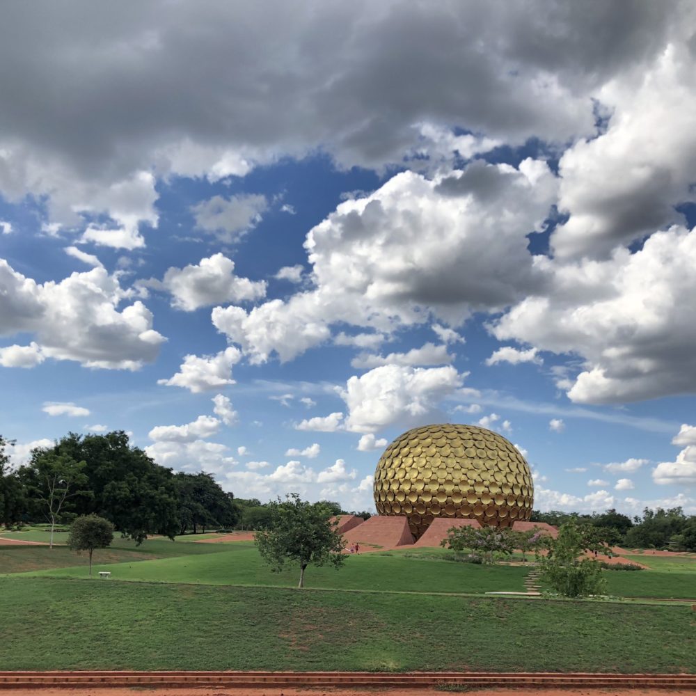
AUROVILLE: Auroville – or the ‘City of Dawn’ – was conceived as a place of research into the ideal of human unity by the Mother, the spiritual collaborator of Sri Aurobindo. The idea is to build a futuristic city where people of goodwill can live together in peace and progressive harmony, above all creeds, all politics and all nationalities. Auroville came into existence in 1968. Its Charter says, “To live in Auroville one must be a willing servitor of the Divine Consciousness”, and describes it as “belonging to nobody in particular, but to humanity as a whole”; as a place “of constant progress”; and as “a bridge between the past and the future.”
TEMPLES IN PUDUCHERRY: Though the temples in Puducherry are not as well known they are charming in their own unique way. They are Manakula Vinayagar Koil, Varadaraja Perumal Temple, Vedhapureeswarar Temple, Kanniga Parameswari Temple, Kamatchiamman Temple, and Sri Gokilambal Thirukameshwara Temple
CHURCHES IN PUDUCHERRY : Christianity is a way of life for many here and it can be seen from the no. of churches around- Church of the Sacred Heart of Jesus, Church of the Capuchins, Notre Dame de’, Church of the Assumption, The Church of Our Lady of Lourdes, Church of Our Lady of Good Health.
MOSQUES IN PUDUCHERRY: Plenty of mosques also Donne the streetscape of Puducherry. They are JAMAI MOSQUE, MEERAN MOSQUE, KUTHBHA MOSQUE, MULLA MOHHAMED MOSQUE, and HERITAGE
BUILDINGS AND MONUMENTS
BEACH ROAD: No visit to Puducherry is complete without a walk along beach road. Friday, Saturday and Sunday and holiday evening are busiest. The Police close both end of the road for vehicular traffic. Beach road has little of architectural interest, but oceans of simple charm and officially called Goubert Avenue.
THE MAIRIE: Located on Goubert Avenue, this charming white building, facing the sea almost transports you to France. Use your imagination a little and you could very well be on a French sea side resort
LE CAFÉ: It was once the port office when the railway ran along Beach Road from the South Boulevard to the old 240 meters iron pier. A cyclone in 1952 largely destroyed the pier whose remains can still be seen poking out of the water.
GANDHI STATUE: This is a highlight of Puducherry. A four-meter statue of Mahatma Gandhi is surrounded by eight magnificent granite pillars, which were supposedly brought from Gingee, a fort some 70 Kms. from Puducherry.
FRENCH WAR MEMORIAL: The French War Memorial on Goubert Avenue is solemn reminder of those brave soldiers who laid down their lives, for their country during the First World War. Every year on the 14th July (Bastille Day) the memorial is beautifully illuminated and homage is paid to those brave martyrs.
NEHRU STATUE: Located across the street from the imposing Gandhi statue, the statue is also flanked by four pillars from Gingee. The space in front plays host to various cultural, musical and commercial activities through the year.
19TH CENTURY LIGHT HOUSE: This light house was used for the first time on July 1st 1836 and continued to be used upto the year 1979. This now- abandoned lighthouse stands on the edge of the sea.
FRENCH CONSULATE: French Consulate General is the only diplomatic mission in town. This colonial building has changed over the years, and yet manages to retain some of its original 18th Century charm. The consulate is open to French citizens.
AROUND BHARATHI PARK: The park located in the heart of Puducherry, is one of the most beautiful public spots in Puducherry, with its lush green surroundings and shady trees providing succor from the harsh Puducherry sun to many a weary soul.
AAYI MANDAPAM: This gleaming white monument built during the time of Napoleon III, Emperor of the France. The monument commemorates both the provision of water to the French city during his reign and the good deed of a lady some 300 years before.
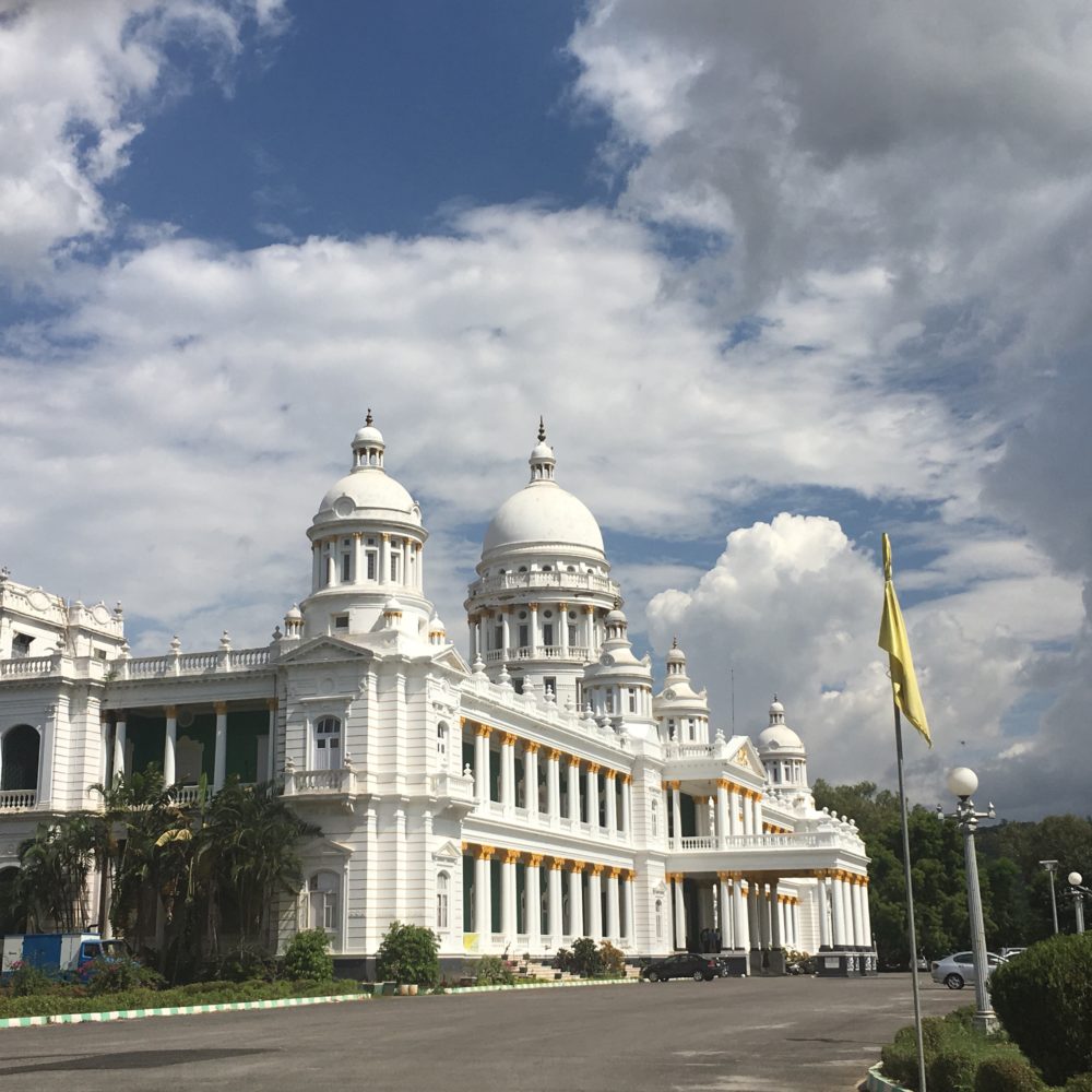
RAJ NIWAS: The Government House (Raj Niwas) is a harmonious blend of French and Indian style of architecture. Once the location of the Hotel de la Compagnie (the French trading company that ruled in Puducherry from its first settlement in 1674 until the French government took over in 1769) and later played host to Duplex. It is now the Lieutenant Governor’s residence
ROMAIN ROLLAND LIBRARY: The Romain Rolland library was established in 1872 and has a rich collection of more than 3, 00,000 volumes in both French and English. It also boasts of a mobile library service which has a collection of more than 8000 books. These books are taken to nearby villages by bus, in order to make the books more accessible to the common man. The library also houses some rare editions of books
UCO BANK: The UCO Bank, which dates from 1916 when it was La Banque de l’ Indochine, preserves for those who wish to change money there a gentle reminder of the complexity of the British ledger system, dead in London but alive and well in Pondy.
LEGISLATIVE ASSEMBLY: It was established in 1962 in what was formerly a private house.
CERCLE DE PUDUCHERRY: It is a private club, established for senior French notables in 1899. The activities of its 400 members can be glimpsed through its gate and high, open windows.
ASHRAM DINING ROOM: Ashram Dining Room has prepared the food for Ashramites and their guests since 1934. It sits on land once
occupied by Governor Dumas in 1735. Even after many reconstructions, it reflects its architectural heritage.
PUDUCHERRY MUSEUM: Puducherry Museum is open from 1000-1700 hrs on all days but Monday and public holidays. It is located in the former residence of the French Administrator building. The Museum is well worth seeing as a fine example of a grand two-storey residence as well as for most of its exhibits. The museum has a collection of rare bronzes and stone sculptures from the Pallava and Chola dynasties and artifacts excavated from Arikamedu, including remnants of Greek and Roman jars, 200 year old beads made from glass and precious stones and even objects from the Tsung period in China. The museum also has a Geology room, a shell and fossil room and a collection of handicrafts, coins, church relics and French furniture.
THE CHURCH OF OUR LADY OF THE ANGELS AT DUMAS STREET: Built in 1855, this is the Greek Roman architectural style. Its façade, flanked by two unadorned square towers faces east towards the ocean. The interior is roofed by a barrel vault, with a great dome rising over the crossing. The pastel peach and lime colours give it a very serene appearance. This church is also famous for its rare oil painting of Our Lady of the Assumption, which was a gift from the French emperor, Napoleon III.
THE STATUE OF JOAN OF ARC AT DUMAS STREET: Another example of the French influence in Puducherry is a marble statue of the heroic French damsel Joan d’Arc, which is located in front of the Church of Our Lady of the Angles.
THE FRENCH INSTITUTE OF THE FAR EAST AT DUMAS STREET (L’ECOLE FRANCAISE D’EXTREME ORIENT): This is an internationally renowned research institute. This institute has two impressive and handsome buildings almost diagonal to each other at the corner of Dumas Street and is known for its research in the field of Indology, history and archaeology.
HOTEL DE L’ORIENT AT ROMAIN ROLLAND STREET: Built in 1809, was once the Directorate of Education and is now a hotel-restaurant-gift shop into which you might express your interest in its retrofitted charm even if you aren’t a guest.
HOTEL LAGRENEE DE MEZIERE AT ROMAIN ROLLAND STREET (SAINT JOSEPH DE CLUNY): Built in 1774 and once a private house, this classic colonial building was donated to the religious order of Saint Joseph de Cluny some 150 years ago.
CURIO CENTRE AT ROMAIN ROLLAND STREET: A leading shop for antique furniture and curios. The remarkable dimensions of the interior rooms, which interconnect directly with each other, are notable.
ALLIANCE FRANCAISE AT SUFFREN STREET: This very public and busy place houses a cultural and information centre, a school for the teaching of the French language and a library.
SAINT ANTHONY’S SHRINE AT SUFFREN STREET: This is the most interesting of several small shrines in Pondy. This is one Christian place of worship where footwear is removed before entering.
PUBLIC WORKS DEPARTMENT AT BUSSY STREET: This classic colonial Government building is notable for entrance gate, compound wall, balcony with ironwork and brackets and high arched windows.
LYCEE FRANCAIS AT VICTOR SIMONEL STREET: It established in 1826, this institute still imparts education to hundreds of Pondicherrians in French. Special permission is required to visit this colonial place, with its well preserved shady courtyard, columns and balconies. It also has an interesting collection of old photographs of colonial Puducherry and collection of very rare coins of the French East Indian Company.
SRI AUROBINDO ASHRAM AT MARINE STREET: The Samadhi is located in the Ashram where Sri Aurobindo and the Mother worked for many years. Visitors are allowed between 08.00 – 12.00 and 14.00 – 16.00 every day.
SRI AUROBINDO INTERNATIONAL CENTRE OF EDUCAITON AT MARINE STREET: It is notable for its entrance gate with courtyard, arched windows and parapet.
LE FOYER DU SOLDAT AT LAW DE LAURISTON STREET: This is the legion hall for retired soldiers from Puducherry, who waged wars on behalf of France in Europe and the colonies. The building is interesting, with a dash of colours added to it in the form of the ‘tricouleur’ (red, white, and blue flag) fluttering in the wind.
FRENCH INSTITUTE AT SAINT-LOUIS STREET: The classical colonial building is a research institute in Indian Civilization, history and society in ecology, in environment and development in South and Southeast Asia. The Centre of Indology focuses on Indian languages as a central part of India’s cultural heritage. They are preserving lot of palm leaf manuscripts. The building is notable for its entrance gate with pediment, arched staircases, arcades, windows.
ANANDA RANGA PILLAI HOUSE: The single most famous house of the Tamil-French style was built in 1735 across the street Ananda Rangapillai by the chief Dubash of Duplex the Governor of Puducherry. Its architecture represents an unusual fusion of French and Indian styles. This once lavishly furnished house offered fascinating glimpses into a bygone era and vanished lifestyle. However, today it has fallen upon hard times and retains very little of its former. Special permission is required to visit the mansion.
STREETSCAPE: The Vysial Street between Mission Street and M.G.Road has the remaining core of Hindu Tamil houses maintaining the earliest fusion with European style. Some of the houses in this traditional neighborhood of rich merchants are 250 years old. It has the feature of ‘thinnai’ (a flat-ceiling platform built into the façade and supported by large wooden columns), ‘mutram’ (a central open courtyard surrounded by a colonnaded roofed space) and ‘thalvaram’ (a tiled roof extending from the sloping roof to posts or pillars at the curb, sheltered people from intense rain or shine.
Pondicherry Tourism is famous for its french colonial history and auroville. Explore Puducherry at http://www.pondytourism.in/